1943 Map of Tranquility
USGS Topo · Published 1943About this map
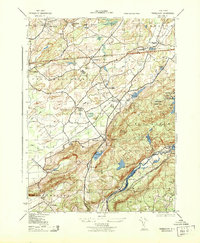
The Pequest River and the Musconetcong River carve through the landscape of northern New Jersey, anchoring a network of small agricultural hamlets and early industrial corridors. At the height of the World War II era, this region remained heavily defined by its 19th-century infrastructure, including the Delaware Lackawanna and Western RR and the Lehigh and Hudson River RR. Local spiritual life is evident in landmarks like the Quaker Church and the Yellow Frame Church, while the presence of the Green Cons School and Allamuchy Twp School indicates the organized rural school districts of the time.
Find a feature on this map
44 named features on this map. Tap any name to fly to it.
Don’t see what you’re looking for? This feature index may not catch every label — zoom into the map to look around manually.
Map Details
Editions of this 1943 Tranquility Map
This is the sole edition of this map. No revisions or reprints were ever made.
Other maps of this area

1888 · Franklin
USGS Topo · 1:62,500

1888 · Hackettstown
USGS Topo · 1:62,500

1888 · Lake Hopatcong
USGS Topo · 1:62,500

1891 · Wallpack
USGS Topo · 1:62,500

1893 · Wallpack
USGS Topo · 1:62,500

1894 · Hackettstown
USGS Topo · 1:62,500

1894 · Lake Hopatcong
USGS Topo · 1:62,500

1894 · Franklin
USGS Topo · 1:62,500

1897 · Franklin
USGS Topo · 1:62,500

1898 · Lake Hopatcong
USGS Topo · 1:62,500