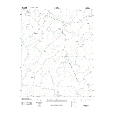
2010 Map of Tranquillity
USGS Topo · Published 2010About this map
Tranquillity Methodist Church and its adjacent cemetery sit at a central crossroads in Meigs County, serving as a focal point for a landscape defined by ridges and narrow hollows. The terrain transitions from the eastern slopes of Newman Ridge and Kennedy Ridge down toward the backwaters of Chickamauga Lake in the northwest. This 2010 survey highlights a pattern of rural settlement deeply rooted in community institutions, evidenced by the high density of family and church-affiliated burial grounds such as Hickory Flat Cemetery, Buttram Cemetery, and Goddard Cemetery.
Find a feature on this map
76 named features on this map. Tap any name to fly to it.
Don’t see what you’re looking for? This feature index may not catch every label — zoom into the map to look around manually.
Map Details
Editions of this 2010 Tranquillity Map
This is the sole edition of this map. No revisions or reprints were ever made.
Other maps of this area

1886 · Cleveland
USGS Topo · 1:125,000

1887 · Kingston
USGS Topo · 1:125,000

1891 · Kingston
USGS Topo · 1:125,000

1892 · Cleveland
USGS Topo · 1:125,000

1893 · Kingston
USGS Topo · 1:125,000

1895 · Cleveland
USGS Topo · 1:125,000

1901 · Cleveland
USGS Topo · 1:125,000
1935 · Niota
USGS Topo · 1:24,000
1935 · Athens
USGS Topo · 1:24,000
1935 · Goodfield
USGS Topo · 1:24,000