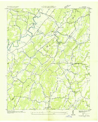
1942 Map of Tranquillity
USGS Topo · Published 1942About this map
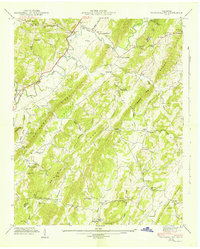
MC Minn Ridge and Pone Ridge define the corrugated topography of this rural Tennessee landscape, where the settlements of Tranquillity and Bogge Crossroad serve as small hubs for a dispersed agricultural community. The 1941 field examination recorded a dense network of local institutions, including Hickory Flats Sch, Turkeypen Sch, and Walnut Grove Sch, indicating a well-populated countryside before mid-century consolidation. Water power and local industry are evidenced by Collins Mill along the South Fork Little Sewee Cr. The area is rich in genealogical landmarks, such as the Old Walnut Grove Cem and Goddard Cem, alongside numerous churches like Peak Chapel and Buttram Ch. The landscape is further shaped by the winding courses of Big Sewee Creek and Ten Mile Creek, which cut through the ridges towards the Meigs and McMinn county line.
Find a feature on this map
53 named features on this map. Tap any name to fly to it.
Don’t see what you’re looking for? This feature index may not catch every label — zoom into the map to look around manually.
Map Details
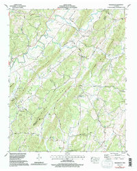
Editions of this 1942 Tranquillity Map
This is the sole edition of this map. No revisions or reprints were ever made.
Historical Maps of Clearwater Through Time
5 maps found