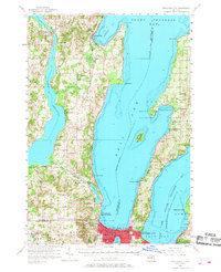
1957 Map of Traverse City
USGS Topo · Published 1968About this map
The West and East Arms of Grand Traverse Bay define the geography of this mid-century survey, centered on the growth of Traverse City and the rural reaches of the Peninsula. The city's post-war infrastructure is evident in the development of the Traverse City Airport and Northwestern Michigan College, while recreational spaces like Clinch Park Zoo and the Drive-in Theater near Acme reflect the era's cultural landscape.
Find a feature on this map
77 named features on this map. Tap any name to fly to it.
Don’t see what you’re looking for? This feature index may not catch every label — zoom into the map to look around manually.
Map Details
Editions of this 1957 Traverse City Map
2 editions found
Other maps of this area

1954 · Central Lake
USGS Topo · 1:62,500

1954 · Traverse City
USGS Topo · 1:250,000

1955 · Cheboygan
USGS Topo · 1:250,000

1956 · Fife Lake
USGS Topo · 1:62,500

1956 · Kingsley
USGS Topo · 1:62,500

1956 · Thompsonville
USGS Topo · 1:62,500

1957 · Traverse City
USGS Topo · 1:62,500

1957 · Northport
USGS Topo · 1:62,500

1957 · Maple City
USGS Topo · 1:62,500

1957 · Elk Rapids
USGS Topo · 1:62,500
Featured Places
- Garfield Township, MI
- Traverse City, MI
- East Bay Township, MI
- Long Lake Township, MI
- Peninsula Township, MI