
Loading...
Loading map...1989 Map of Traverse City
USGS Topo · Published 1990About this map
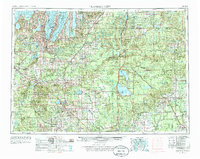
Lake Michigan dominates the northwestern edge of this 1980s landscape, where the deep indentations of Grand Traverse Bay frame the region's urban center at Traverse City. The survey documents a complex network of glacial lakes and river systems, from the massive Houghton Lake and Higgins Lake in the interior to the Manistee River and Au Sable River that define the central watershed.
Find a feature on this map
135 named features on this map. Tap any name to fly to it.
Don’t see what you’re looking for? This feature index may not catch every label — zoom into the map to look around manually.
Map Details
Date Portrayed1989
Date Published1990
PublisherU.S. Geological Survey
Map TypeTopographic
Scale1:250,000
Physical Dimensions32.2 x 22.1 inches
Editions of this 1989 Traverse City Map
This is the sole edition of this map. No revisions or reprints were ever made.
Historical Maps of Garfield Township Through Time
5 maps found

Featured Locations
- East Bay Township, MI
- Garfield Township, MI
- Traverse City, MI
- East Bay Charter Township, East Bay Township
- Garfield Charter Township, Garfield Township
Source Details
SourceU.S. Geological Survey
CopyrightPublic Domain