
1932 Map of Freesoil SE
USGS Topo · Published 1932About this map
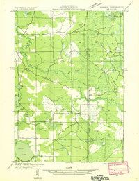
The Big Sable River and Little Sable River dominate this 1932 landscape, carving through the timbered sections of Meade and Sherman townships. This advance sheet, compiled from early Air Corps aerial photography, reveals a network of waterways and wetlands that includes Duck Marsh and a chain of interior lakes such as Lake George, Burley Lake, and Cedar Lake. At the center of the local community, the settlement of Millerton sits near the riverbanks, while the southern portion of the sheet is anchored by Round Lake and the nearby Round Lake Sch. The map effectively shows the transition from organized township grids to the irregular, water-heavy terrain typical of this part of West Michigan, punctuated by isolated landmarks like the local Town Hall.
Find a feature on this map
27 named features on this map. Tap any name to fly to it.
Don’t see what you’re looking for? This feature index may not catch every label — zoom into the map to look around manually.
Map Details
Editions of this 1932 Freesoil SE Map
2 editions found
Other maps of this area

1931 · Custer NW
USGS Topo · 1:31,680

1931 · Baldwin NW
USGS Topo · 1:31,680

1931 · Custer NE
USGS Topo · 1:31,680

1931 · Freesoil SW
USGS Topo · 1:31,680

1933 · Peacock SW
USGS Topo · 1:31,680

1933 · Peacock NW
USGS Topo · 1:31,680

1954 · Traverse City
USGS Topo · 1:250,000

1954 · Milwaukee
USGS Topo · 1:250,000

1954 · Midland
USGS Topo · 1:250,000

1954 · Manitowoc
USGS Topo · 1:250,000