
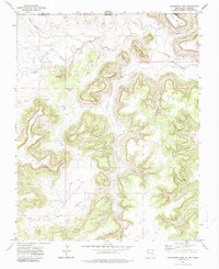
1972 Map of Travesser Park
USGS Topo · Published 1974About this map
Travesser Park and the surrounding mesa country of the High Plains define this borderlands landscape where New Mexico meets Colorado. Mapped from 1970 aerial photography, the terrain is characterized by deep drainage systems like Cooty Canyon and Miller Canyon that carve into the elevated plateaus. The Cimarron River and its tributary Travesser Creek dictate the local geography, with the Dry Cimarron River following the northern boundary near the state line. Evidence of human activity is sparse but specific, marked by a remote Landing Strip, a Gaging Sta on the river, and scattered ranch infrastructure such as a Water Tank and a Well. Significant elevation markers like Jesus Mesa and Baldy Hill provide prominent landmarks across the dissected landscape, while primitive routes like the Deer Trail and various jeep trails provide the only access through the rugged canyons.
Find a feature on this map
25 named features on this map. Tap any name to fly to it.
Don’t see what you’re looking for? This feature index may not catch every label — zoom into the map to look around manually.
Map Details
Editions of this 1972 Travesser Park Map
2 editions found
Other maps of this area

1891 · Mesa De Maya
USGS Topo · 1:125,000

1892 · Mt Carrizo
USGS Topo · 1:125,000

1893 · Mesa de Maya
USGS Topo · 1:125,000

1954 · Dalhart
USGS Topo · 1:250,000

1955 · La Junta
USGS Topo · 1:250,000

1958 · La Junta
USGS Topo · 1:250,000

1958 · Dalhart
USGS Topo · 1:250,000

1962 · Dalhart
USGS Topo · 1:250,000

1968 · La Junta
USGS Topo · 1:250,000
1972 · Guy
USGS Topo · 1:24,000