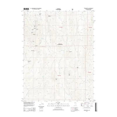
2014 Map of Treasure Hill
USGS Topo · Published 2014About this map
The rugged topography of the White Pine Range defines this part of Nevada, where the legacy of silver mining is written into the names of the landscape. High elevations center on Treasure Hill, surrounded by a series of flats with mineral-rich names like Bromide Flat, Chloride Flat, and Pogonip Flat. These sites, along with the Wheeler Tunnel and Eberhardt Tunnel, point to the intensive subsurface exploration that once characterized the district. The map shows the transition from the Mokomoke Mountains in the north down toward the Lampson Canyon area, all largely contained within the boundaries of the Humboldt National Forest.
Find a feature on this map
40 named features on this map. Tap any name to fly to it.
Don’t see what you’re looking for? This feature index may not catch every label — zoom into the map to look around manually.
Map Details
Editions of this 2014 Treasure Hill Map
This is the sole edition of this map. No revisions or reprints were ever made.
Other maps of this area

1949 · Treasure Hill
USGS Topo · 1:62,500

1950 · Treasure Hill
USGS Topo · 1:62,500

1951 · Green Springs
USGS Topo · 1:62,500

1951 · Illipah
USGS Topo · 1:62,500

1951 · Pancake Summit
USGS Topo · 1:62,500

1956 · Ely
USGS Topo · 1:250,000

1959 · Ely
USGS Topo · 1:250,000

1963 · Ely
USGS Topo · 1:250,000

1979 · Mt. Hamilton
USGS Topo · 1:100,000
1990 · Seligman Canyon
USGS Topo · 1:24,000