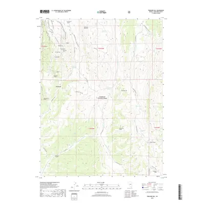
2018 Map of Treasure Hill
USGS Topo · Published 2018About this map
The high peaks of the White Pine Range and Mokomoke Mountains dominate this survey, which preserves the intricate layout of a 19th-century silver mining district in the modern era. Centered on the rugged Treasure Hill, the map details a complex network of historic access routes and industrial features including the Siegel Mine and the Hidden Treasure Mine. The settlement of Eberhardt remains a focal point, connected to specialized terrain via the Eberhardt Tunnel and the Eberhardt Site Trail. Local history and genealogy are supported by the presence of several cemetery markers, specifically the S Cem Trail, N Cem Trail, and South Cem Trail. These paths, alongside major topographic features like Chloride Flat and Pogonip Flat, reveal the systematic approach taken by early prospectors to navigate and extract wealth from this high-elevation Nevada landscape.
Find a feature on this map
62 named features on this map. Tap any name to fly to it.
Don’t see what you’re looking for? This feature index may not catch every label — zoom into the map to look around manually.
Map Details
Editions of this 2018 Treasure Hill Map
This is the sole edition of this map. No revisions or reprints were ever made.
Other maps of this area

1949 · Treasure Hill
USGS Topo · 1:62,500

1950 · Treasure Hill
USGS Topo · 1:62,500

1951 · Green Springs
USGS Topo · 1:62,500

1951 · Illipah
USGS Topo · 1:62,500

1951 · Pancake Summit
USGS Topo · 1:62,500

1956 · Ely
USGS Topo · 1:250,000

1959 · Ely
USGS Topo · 1:250,000

1963 · Ely
USGS Topo · 1:250,000

1979 · Mt. Hamilton
USGS Topo · 1:100,000
1990 · Seligman Canyon
USGS Topo · 1:24,000