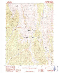
1990 Map of Treasure Hill
USGS Topo · Published 1990About this map
Treasure Hill stands as the high-elevation center of this mineral-rich region within the Humboldt National Forest. By the late 20th century, the landscape preserved the industrial footprints of a previous silver boom, marked by the sites of Treasure City and Eberhardt. The mining infrastructure is densely concentrated on the western slopes, where subterranean networks are indicated by the Wheeler Tunnel, Eberhardt Tunnel, and several workings including the Hidden Treasure Mine and Aurora Mine.
Find a feature on this map
37 named features on this map. Tap any name to fly to it.
Don’t see what you’re looking for? This feature index may not catch every label — zoom into the map to look around manually.
Map Details
Editions of this 1990 Treasure Hill Map
This is the sole edition of this map. No revisions or reprints were ever made.
Other maps of this area

1949 · Treasure Hill
USGS Topo · 1:62,500

1950 · Treasure Hill
USGS Topo · 1:62,500

1951 · Green Springs
USGS Topo · 1:62,500

1951 · Illipah
USGS Topo · 1:62,500

1951 · Pancake Summit
USGS Topo · 1:62,500

1956 · Ely
USGS Topo · 1:250,000

1959 · Ely
USGS Topo · 1:250,000

1963 · Ely
USGS Topo · 1:250,000

1979 · Mt. Hamilton
USGS Topo · 1:100,000
1990 · Seligman Canyon
USGS Topo · 1:24,000