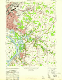
1947 Map of Trenton East
USGS Topo · Published 1947About this map
The Delaware River defines the western edge of this post-war landscape, where industrial Trenton gives way to emerging residential developments. Following the Pennsylvania Railroad corridor, the map captures a transition from urban centers to pockets like Warner Village and DeCou Village. Significant institutional footprints are visible, including the Donnelly Memorial Hospitals and the Pennsylvania Maritime Academy situated near Sucker Point. The map also details a network of cemeteries and parks, such as St Marys Cemetery and Chewalla Park, illustrating the social infrastructure supporting these growing New Jersey communities.
Find a feature on this map
86 named features on this map. Tap any name to fly to it.
Don’t see what you’re looking for? This feature index may not catch every label — zoom into the map to look around manually.
Map Details
Editions of this 1947 Trenton East Map
This is the sole edition of this map. No revisions or reprints were ever made.
Other maps of this area

1888 · Bordentown
USGS Topo · 1:62,500

1888 · Princeton
USGS Topo · 1:62,500

1890 · Lambertville
USGS Topo · 1:62,500

1890 · Burlington
USGS Topo · 1:62,500

1891 · Lambertville
USGS Topo · 1:62,500

1893 · Bordentown
USGS Topo · 1:62,500

1893 · Burlington
USGS Topo · 1:62,500

1894 · Princeton
USGS Topo · 1:62,500

1894 · Lambertville
USGS Topo · 1:62,500

1904 · Burlington
USGS Topo · 1:62,500