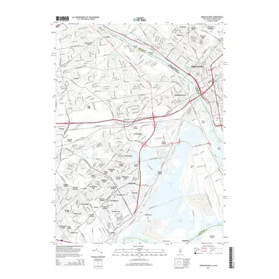
2014 Map of Trenton West
USGS Topo · Published 2014About this map
The Delaware River serves as the central artery for this 2014 survey, dividing the bustling state capital of Trenton from the expanding residential and industrial corridors of Bucks County. Significant transport infrastructure defines the landscape, from the historic Delaware and Raritan Canal to the modern reach of the Lincoln Hwy. On the New Jersey side, the dense urban grid surrounds Thomas Edison State Coll and Mercer Cem, while Pennsylvania features a complex network of planned neighborhoods such as Magnolia Hill, Birch Valley, and Holly Hill. The map records an intricate water system beyond the river, including the expansive Van Sciver Lake and several named channels like the Trenton Channel and Penn Channel that frame river islands such as Biles Island and Rotary Island.
Find a feature on this map
93 named features on this map. Tap any name to fly to it.
Don’t see what you’re looking for? This feature index may not catch every label — zoom into the map to look around manually.
Map Details
Editions of this 2014 Trenton West Map
This is the sole edition of this map. No revisions or reprints were ever made.
Other maps of this area

1888 · Bordentown
USGS Topo · 1:62,500

1888 · Princeton
USGS Topo · 1:62,500

1890 · Lambertville
USGS Topo · 1:62,500

1890 · Burlington
USGS Topo · 1:62,500

1891 · Lambertville
USGS Topo · 1:62,500

1893 · Bordentown
USGS Topo · 1:62,500

1893 · Burlington
USGS Topo · 1:62,500

1894 · Princeton
USGS Topo · 1:62,500

1894 · Lambertville
USGS Topo · 1:62,500

1904 · Burlington
USGS Topo · 1:62,500
Featured Places
- Hamilton Township, NJ
- Trenton, NJ
- Levittown, Bristol Township
- Middletown Township, PA
- Ewing Township, NJ