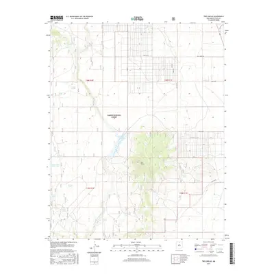
2017 Map of Tres Orejas
USGS Topo · Published 2017About this map
Tres Orejas rises as the central topographic feature of this high-altitude landscape in Taos County, where the desert plateau meets the eastern edge of the Carson National Forest. The map documents a complex system of water management essential for livestock and local agriculture, characterized by numerous catchment basins including Carson Reservoir, Torres Tank, and Borrego Tank. The drainage patterns are defined by seasonal watercourses like Arroyo Aguaje de la Petaca, which carve through the arid terrain. Settlement patterns here show an interesting mix of traditional land use and modern developments, evidenced by unconventional road names such as Earthship Way and Skid Row. This intersection of rugged natural geography and distinct local naming conventions provides a clear record of how this portion of northern New Mexico has been utilized and subdivided into the twenty-first century.
Find a feature on this map
34 named features on this map. Tap any name to fly to it.
Don’t see what you’re looking for? This feature index may not catch every label — zoom into the map to look around manually.
Map Details
Editions of this 2017 Tres Orejas Map
This is the sole edition of this map. No revisions or reprints were ever made.
Other maps of this area

1954 · Raton
USGS Topo · 1:250,000

1958 · Raton
USGS Topo · 1:250,000

1960 · Taos Junction
USGS Topo · 1:24,000

1961 · Carson
USGS Topo · 1:24,000

1961 · Tres Orejas
USGS Topo · 1:24,000

1961 · Servilleta Plaza
USGS Topo · 1:24,000

1963 · Arroyo Hondo
USGS Topo · 1:24,000

1963 · Cerro De Los Taoses
USGS Topo · 1:24,000
1963 · Petaca Peak
USGS Topo · 1:24,000

1964 · Los Cordovas
USGS Topo · 1:24,000