
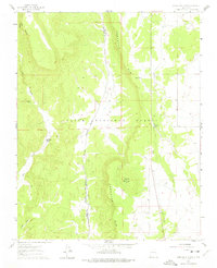
1961 Map of Servilleta Plaza
USGS Topo · Published 1963About this map
Servilleta Plaza serves as the primary settlement hub in this 1961 survey, situated along the winding course of the Rio Tusas. The landscape is defined by the sharp elevation changes of the Comanche Rim and the deep incision of Comanche Canyon, marking a rugged transition within the Carson National Forest. The map captures a distinct moment in Northern New Mexico’s infrastructure, showing the Old Railroad Grade running parallel to modern Route 285. This juxtaposition of the abandoned rail line and the primary highway illustrates the shift in high-country transportation during the mid-20th century. Topographic details like Cerro Mojino and Cañon Seco dominate the central terrain, while small-scale land use is noted by features such as Peña Tank and a local Gravel Pit.
Find a feature on this map
15 named features on this map. Tap any name to fly to it.
Don’t see what you’re looking for? This feature index may not catch every label — zoom into the map to look around manually.
Map Details
Editions of this 1961 Servilleta Plaza Map
2 editions found
Other maps of this area

1918 · Abiquiu
USGS Topo · 1:125,000

1918 · Tusas
USGS Topo · 1:125,000

1953 · La Madera
USGS Topo · 1:24,000

1953 · Ojo Caliente
USGS Topo · 1:24,000

1954 · Raton
USGS Topo · 1:250,000

1954 · Aztec
USGS Topo · 1:250,000

1958 · Raton
USGS Topo · 1:250,000

1958 · Aztec
USGS Topo · 1:250,000

1960 · Taos Junction
USGS Topo · 1:24,000

1961 · Carson
USGS Topo · 1:24,000