Old Maps of Rio Arriba County, New Mexico
Explore 884 old maps of Rio Arriba County, spanning from 1889 to today. These high-resolution historic maps reveal how streets, neighborhoods, landmarks, and natural features evolved over time — perfect for genealogy, metal detecting, research, and local history exploration.
What you can do with these maps:
- See how Rio Arriba County changed over time: Compare historical maps to modern-day views to trace roads, homesites, rail lines & more.
- View detailed metadata: Each map includes creators, publishers, year, scale, and archive source.
- Overlay maps with satellite & LiDAR: Visualize the past alongside modern tools to explore terrain & human change.
- Trusted historical sources: Maps sourced from the USGS, Library of Congress, and other archives.
- Access maps your way: View online, download high-res files, or order prints for personal or research use.
Start exploring old maps of Rio Arriba County to uncover forgotten places, hidden landmarks, and the deep history beneath your feet.
Rio Arriba County, NM maps
(884)- 1889 Map of Largo
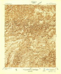
 1889 Largo1889 Print · USGSNorthwestern New Mexico in the late nineteenth century shows a vast network of desert canyons and river valleys before modern development. Genealogists and researchers can trace early settlements like Bloomfield and Largo or locate landmarks such as Angels Peak and the remote Stinking Lakes Sinks.
 - 1889 Map of Santa Fe, 1963 Print
 1889 Santa Fe1963 Print · USGSSanta Fe and the surrounding high country appear here in the late nineteenth century as the railroad began transforming the territory. Genealogists and historians can trace early settlements like Santuario, identify family sites at Gonzales Ranch, and locate the historic Old Fort Marcy.
 - 1890 Map of Jemes
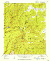
 1890 Jemes1890 Print · USGSUpper New Mexico in the late nineteenth century was a land of high mesas and ancient pueblo sites along the Jemes Creek drainage. Researchers can trace the early layout of Jemes Pueblo, the location of the San Miguel Mine, and traditional springs like Ojo del Oso.2 unique versions available
 - 1892 Map of Jemes
 1892 Jemes1892 Print · USGSThe high canyons and pueblos of northern New Mexico are documented here in the late 1880s, shortly after the region's territorial reorganization. Researchers can trace the early footprint of Jemes Pueblo, locate the San Miguel Mine, and identify remote springs like Ojo del Espiritu Santo.4 unique versions available
 - 1892 Map of Santa Clara
 1892 Santa Clara1892 Print · USGSUpper New Mexico at the end of the nineteenth century reveals a landscape shaped by the Rio Grande and the arrival of the rails. Genealogists and historians can trace traditional settlements like San Ildefonso and Peña Blanca alongside the burgeoning Santa Fé Southern Railway.4 unique versions available
 - 1894 Map of Santa Fe
 1894 Santa Fe1894 Print · USGSSanta Fe and its surrounding high-country villages appear here during the territorial era of the late nineteenth century. Genealogists and historians can trace the routes of early railroads and locate specific landmarks like Old Fort Marcy, Gonzales Ranch, and Tesuque Pueblo.5 unique versions available
 - 1895 Map of Largo, 1897 Print
 1895 Largo1897 Print · USGSNorthwestern New Mexico appears as a rugged frontier of canyons and high peaks in the years before statehood. Researchers can trace early settlements at Bloomfield and Largo or locate iconic landmarks such as El Huerfano and the headwaters of Canon Largo.3 unique versions available
 - 1909 Map of Gallina
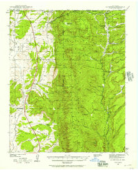
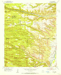
 1909 Gallina1909 Print · USGSUpper New Mexico at the end of the territorial era is captured here, showing the remote ranching and mining country along the Continental Divide. Genealogists and historians can locate early homesteads like Hart Ranch, the mining-era Copper City, and ancient Cliff Dwellings.2 unique versions available
 - 1913 Map of Summitville, 1962 Print
 1913 Summitville1962 Print · USGSThe high San Juan Mountains at the turn of the century are captured here, from the gold-mining district at Summitville to the ranchlands of the Navajo River valley. Genealogists and historians can trace early school sites like Blanco School and working mines including the Asiatic Mine and Forest King Mine.
 - 1915 Map of Summitville
 1915 Summitville1915 Print · USGSSouthern Colorado mining and timber operations are captured here during the early twentieth century. Researchers can trace remote mining claims like the Asiatic Mine, mountain schools such as Blanco School, and the path of the Logging RR.4 unique versions available
 - 1918 Map of Abiquiu
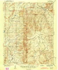
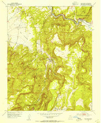
 1918 Abiquiu1918 Print · USGSUpper Rio Arriba County comes alive in the years following the Great War, showing a network of historic land grants and riverside villages. Researchers can trace the path of the D. and R. G. R. R. or locate ancestral roots in Abiquiu, Vallecitos, and San Juan.
 - 1918 Map of Tusas
 1918 Tusas1918 Print · USGSThe high country of Northern New Mexico and the Colorado border is captured here during the First World War. Researchers can trace the Denver and Rio Grande RR through remote stations like Toltec or locate early settlements in the Tierra Amarilla Grant.
 - 1924 Map of Pagosa Springs, 1958 Print
 1924 Pagosa Springs1958 Print · USGSArchuleta County comes into focus in the 1920s as a vital mountain corridor defined by the San Juan and Piedra rivers. Genealogists and historians can trace the Denver and Rio Grande Western rail line and discover remote schoolhouses like Stollsteimer School and O'Neal Park School.2 unique versions available
 - 1927 Map of Pagosa Springs
 1927 Pagosa Springs1927 Print · USGSThe high country of the San Juan Mountains comes into focus in the 1920s as ranching and rail reach into the river valleys. Genealogists and historians can trace the Denver and Rio Grande Western line through Pagosa Junction and locate old rural hubs like Yellowjacket School.3 unique versions available
 - 1937 Map of Jemez Springs
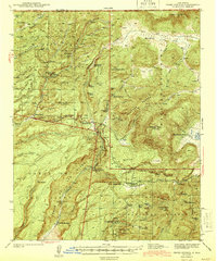
 1937 Jemez Springs1937 Print · USGSThe Jemez Mountains in the late thirties were a landscape of geothermal activity and sprawling land grants. Researchers can trace historic family outposts like Boyd Ranch and Ruiz Ranch or locate New Deal-era sites such as the CCC Camp.
 - 1939 Map of La Ventana, 1957 Print
 1939 La Ventana1957 Print · USGSSandoval County at the end of the Depression era shows a landscape where high-desert ranching meets mountain timber and mining. Genealogists and historians can trace old homesteads and work sites like Señorita, the Luciani Mines, and the Ojitos Logging Camp.2 unique versions available
 - 1940 Map of Cuba, 1962 Print
 1940 Cuba1962 Print · USGSNorthwestern New Mexico’s high country is captured here just before the mid-century, where the Santa Fe National Forest meets early ranching outposts. Researchers can trace ancestral locations at the Gallina Cem, Capulin Sch, and remote sites like Old Mestas Ranch.2 unique versions available
 - 1943 Map of Cuba
 1943 Cuba1943 Print · USGSIn the Sandoval County high country during the early 1940s, ranching outposts and small mountain settlements were the heart of the community. You can trace the locations of historic rural education sites like La Jara Sch and find family landmarks such as Old Meatas Ranch and Vallecito Damian.2 unique versions available
 - 1943 Map of La Ventana
 1943 La Ventana1943 Print · USGSSandoval County during the early 1940s was a landscape defined by high mountain forests and scattered mining outposts. Researchers can trace the legacy of timber and coal through the Ojitos Logging Camp, Luciani Mines, and old schools like Copper City Sch.2 unique versions available
 - 1944 Map of Jemez Springs
 1944 Jemez Springs1944 Print · USGSThe Jemez Mountains and Sandoval County hinterlands in the late thirties show a rugged landscape of geothermal springs and Civilian Conservation Corps projects. Researchers can trace historic family holdings like Martinez Ranch or visit the Battleship Rock CCC Camp and Sulphur Springs.3 unique versions available
 - 1945 Map of Durango
 1945 Durango1945 Print · USGSSouthwest Colorado and Northern New Mexico at mid-century are defined by the high peaks of the San Juan Range and the tribal lands of the Southern Ute. Genealogists and historians can trace the paths of the D & R G W RR and locate local landmarks like Animas City and the Blanco Basin School.3 unique versions available
 - 1952 Map of Jemez Springs, 1954 Print
 1952 Jemez Springs1954 Print · USGSThe Jemez Mountains in the early fifties reveal a landscape of thermal springs and high-altitude ranching within the national forest. Trace the development of local landmarks like Jemez Springs, the Soda Dam, and the early layout of Camp Shaver.3 unique versions available
 - 1952 Map of Puye, 1954 Print
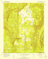
 1952 Puye1954 Print · USGSThe Pajarito Plateau in the early fifties reveals a landscape of deep canyons and ancient heritage. Researchers can locate archaeological sites like the Cliff Dwellings at Puye or trace the early industrial footprint of the General Pumice Mine.4 unique versions available
 - 1953 Map of Canones, 1954 Print
 1953 Canones1954 Print · USGSSpanish land grants still shape the geography of this Rio Arriba territory in the mid-1950s. Genealogists can trace family footprints around Cañones, locating the Capilla de San Miguel, Salazar Ranch, and several local cemeteries.4 unique versions available
 - 1953 Map of Cerro Del Grant, 1954 Print
 1953 Cerro Del Grant1954 Print · USGSRio Arriba County in the early fifties shows a high-altitude landscape of timber camps and alpine meadows within the Santa Fe National Forest. Genealogists and historians can trace old logging sites like Mascareñas Sawmill and the La Grulla Ranch.3 unique versions available
Showing maps 1-25 of 884
Top cities of Rio Arriba County
Frequently asked questions
- What are the different types of historical maps available for Rio Arriba County?
- What is the oldest map of Rio Arriba County?
- Where can I purchase historical maps of Rio Arriba County for my home or office?
- Where can I download high-res historical maps of Rio Arriba County?
- Are there historical topographic maps available for Rio Arriba County?
- Is there historical aerial imagery available for Rio Arriba County?
- Where are historical maps of Rio Arriba County sourced from?