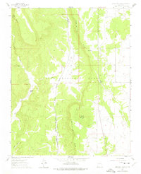
1961 Map of Servilleta Plaza
USGS Topo · Published 1975About this map
Servilleta Plaza is the primary point of settlement in this High Desert landscape, situated along the path of the Rio Tusas. This area, documented in the early 1960s, is defined by the sharp verticality of the Comanche Rim and the volcanic prominence of Cerro Mojino. The map reveals a complex intersection of land boundaries and transportation history, featuring the Petaca Grant Boundary and an Old Railroad Grade that cuts across the eastern plateau. Within the Carson National Forest, the terrain is marked by seasonal water sources like Peña Tank and the rugged descent of Cañon de las Comanches. For genealogists and local historians, the inclusion of a Cem near the plaza offers a specific point of reference for families tied to this high-altitude Taos County community.
Find a feature on this map
15 named features on this map. Tap any name to fly to it.
Don’t see what you’re looking for? This feature index may not catch every label — zoom into the map to look around manually.
Map Details
Editions of this 1961 Servilleta Plaza Map
2 editions found

Other maps of this area

1918 · Abiquiu
USGS Topo · 1:125,000

1918 · Tusas
USGS Topo · 1:125,000

1953 · La Madera
USGS Topo · 1:24,000

1953 · Ojo Caliente
USGS Topo · 1:24,000

1954 · Raton
USGS Topo · 1:250,000

1954 · Aztec
USGS Topo · 1:250,000

1958 · Raton
USGS Topo · 1:250,000

1958 · Aztec
USGS Topo · 1:250,000

1960 · Taos Junction
USGS Topo · 1:24,000

1961 · Carson
USGS Topo · 1:24,000