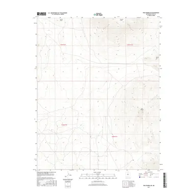
2017 Map of Tres Piedras NE
USGS Topo · Published 2017About this map
Cerro de la Olla dominates the northern skyline of this Taos County high-desert landscape, rising significantly above the surrounding plains. The terrain is characterized by these isolated volcanic peaks and cinder cones, including Cerro Montoso to the southeast and Cerrito Negro near the northern boundary. These landmarks served as vital navigational points for early travelers and shepherds in the region. The map captures a largely open, high-altitude environment in 2017, where the Public Land Survey System grid, including Township 29 North Range 11 East, organizes a territory defined more by its geology than by human settlement. Only a few modern tracks and the small rise of Brushy Mtn break the expanse, reflecting a preservation of the open rangeland character that has defined this part of New Mexico for generations.
Find a feature on this map
8 named features on this map. Tap any name to fly to it.
Don’t see what you’re looking for? This feature index may not catch every label — zoom into the map to look around manually.
Map Details
Editions of this 2017 Tres Piedras NE Map
This is the sole edition of this map. No revisions or reprints were ever made.
Other maps of this area

1954 · Raton
USGS Topo · 1:250,000

1958 · Raton
USGS Topo · 1:250,000

1963 · Arroyo Hondo
USGS Topo · 1:24,000

1963 · Tres Piedras NE
USGS Topo · 1:24,000

1963 · Cerro De La Olla
USGS Topo · 1:24,000

1963 · Sunshine
USGS Topo · 1:24,000

1963 · Cerro De Los Taoses
USGS Topo · 1:24,000
1963 · La Segita Peaks
USGS Topo · 1:24,000

1963 · Guadalupe Mountain
USGS Topo · 1:24,000
1963 · Petaca Peak
USGS Topo · 1:24,000