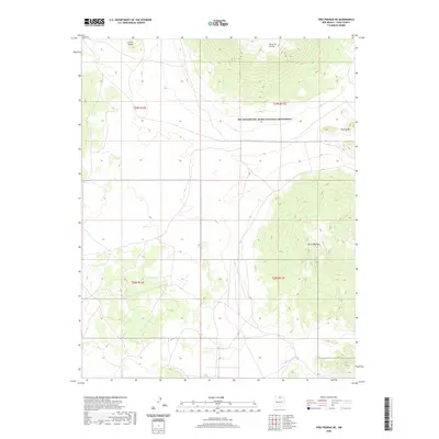
2020 Map of Tres Piedras NE
USGS Topo · Published 2020About this map
Río Grande del Norte National Monument encompasses a significant portion of this Taos County high-desert landscape, preserving a terrain defined by volcanic features and wide volcanic plateaus. Volcanic activity of the past is clearly visible through the prominence of shield volcanoes and cinder cones, most notably the towering Cerro de la Olla in the north and Cerro Montoso to the south. These topographic highs break the relatively flat expanse of the surrounding plains, which are etched with subtle drainage patterns and local depressions. The survey reveals a largely undeveloped region, where the primary human footprint is found in the section lines of the Public Land Survey System, including t29n r11e and t28n r11e. Other notable landmarks that rise above the plateau include Brushy Mtn and the smaller Cerrito Negro near the northern boundary.
Find a feature on this map
9 named features on this map. Tap any name to fly to it.
Don’t see what you’re looking for? This feature index may not catch every label — zoom into the map to look around manually.
Map Details
Editions of this 2020 Tres Piedras NE Map
This is the sole edition of this map. No revisions or reprints were ever made.
Other maps of this area

1954 · Raton
USGS Topo · 1:250,000

1958 · Raton
USGS Topo · 1:250,000

1963 · Arroyo Hondo
USGS Topo · 1:24,000

1963 · Tres Piedras NE
USGS Topo · 1:24,000

1963 · Cerro De La Olla
USGS Topo · 1:24,000

1963 · Sunshine
USGS Topo · 1:24,000

1963 · Cerro De Los Taoses
USGS Topo · 1:24,000
1963 · La Segita Peaks
USGS Topo · 1:24,000

1963 · Guadalupe Mountain
USGS Topo · 1:24,000
1963 · Petaca Peak
USGS Topo · 1:24,000