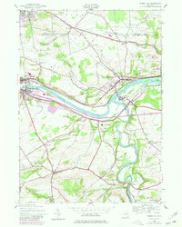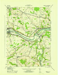
1946 Map of Tribes Hill
USGS Topo · Published 1946About this map
The Mohawk River corridor serves as the central artery of this 1946 mid-century survey, illustrating the complex transit layers of Montgomery County. The Abandoned Erie Canal and the active Barge Canal run parallel to the NYC railroad tracks, framing industrial-era settlements like Fonda and Fultonville. Religious and historical sites are prominent, notably the Auriesville Shrine and the Reparatrix Convent, alongside the colonial-era landmark of Fort Johnson. The landscape is dotted with early 20th-century rural infrastructure, including numerous district schools such as the Cadaughrity Sch and Free Union Sch. South of the river, the winding Schoharie Creek meets the Mohawk near Fort Hunter, while the uplands feature family-linked sites like Switzer Hill and the Wycoff Cem. This map effectively documents the transition from early water-borne commerce to a more modern rail and road network.
Find a feature on this map
50 named features on this map. Tap any name to fly to it.
Don’t see what you’re looking for? This feature index may not catch every label — zoom into the map to look around manually.
Map Details
Editions of this 1946 Tribes Hill Map
This is the sole edition of this map. No revisions or reprints were ever made.
Historical Maps of Johnstown Through Time
7 maps found