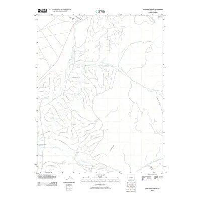
2010 Map of Trinchera Ranch
USGS Topo · Published 2010About this map
Trinchera Ranch occupies a central role in this landscape, where the high desert meets the base of the mountains. This 2010 survey illustrates a complex system of water management and land division, evidenced by the Indian Creek Ditch and the proximity of the Mountain Home Reservoir. The small settlement of Mortimer sits along the northern reaches of Sangre de Cristo Creek, serving as a point of reference in an area defined by extensive ranching and irrigation infrastructure. Numerous private and access roads, such as Berkman Rd and Gerardus Rd, grid the terrain between West Indian Creek and Trinchera Creek. The topography rises toward the southeast near Cat Mountain, while drainage features like American Gulch and Squirrel Canyon detail the local hydrology.
Find a feature on this map
67 named features on this map. Tap any name to fly to it.
Don’t see what you’re looking for? This feature index may not catch every label — zoom into the map to look around manually.
Map Details
Editions of this 2010 Trinchera Ranch Map
This is the sole edition of this map. No revisions or reprints were ever made.
Other maps of this area

1889 · Huerfano Park
USGS Topo · 1:125,000

1892 · Huerfano Park
USGS Topo · 1:125,000

1954 · Trinidad
USGS Topo · 1:250,000

1955 · Trinidad
USGS Topo · 1:250,000

1958 · Trinidad
USGS Topo · 1:250,000

1959 · Trinidad
USGS Topo · 1:250,000

1963 · Mc Carty Park
USGS Topo · 1:24,000

1963 · La Veta Pass
USGS Topo · 1:24,000

1967 · Fort Garland SW
USGS Topo · 1:24,000

1967 · Ojito Peak
USGS Topo · 1:24,000