
1954 Map of Trinidad
USGS Topo · Published 1963About this map
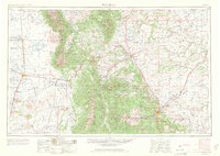
The San Luis Valley dominates the western portion of this mid-century survey, showing the intricate network of the Denver and Rio Grande Western railroad connecting agricultural centers like Alamosa and La Jara. To the east, the dramatic rise of the Sangre de Cristo Mountains is punctuated by towering summits such as Blanca Peak and Culebra Peak, while the Great Sand Dunes National Monument sits at the foot of the range. The landscape transitions from high-desert valley floor to the timbered reaches of the San Isabel National Forest. Local educational history is remarkably well-preserved through the identification of rural institutions like Williams School and Malachite School. Further east, the mining and ranching hubs of Walsenburg and Trinidad anchor the foothills near the iconic West Spanish Peak. Water management for the arid region is visible in features like the Sanchez Reservoir and the winding course of the Rio Grande.
Find a feature on this map
95 named features on this map. Tap any name to fly to it.
Don’t see what you’re looking for? This feature index may not catch every label — zoom into the map to look around manually.
Map Details
Editions of this 1954 Trinidad Map
2 editions found
Other maps of this area

1889 · Canon City
USGS Topo · 1:125,000

1889 · Huerfano Park
USGS Topo · 1:125,000

1891 · Walsenburg
USGS Topo · 1:125,000

1891 · Catlin
USGS Topo · 1:125,000

1891 · Pueblo
USGS Topo · 1:125,000

1891 · Spanish Peaks
USGS Topo · 1:125,000

1891 · Timpas
USGS Topo · 1:125,000

1891 · Nepesta
USGS Topo · 1:125,000

1891 · Apishapa
USGS Topo · 1:125,000

1891 · Mesa De Maya
USGS Topo · 1:125,000