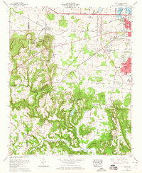
1963 Map of Trinity
USGS Topo · Published 1965About this map
Trinity Mountain and Chestnut Grove Mountain dominate this mid-century portrait of the Alabama landscape west of Decatur. The topography transitions from the high ridges of the mountains down to the shoreline of Wheeler Lake, where the Southern railroad and the Joe Wheeler Highway parallel the water. Small rural communities like Trinity and Wolftown are documented alongside numerous family burial grounds, including Wimbley Cem, Lile Cem, and Sykes Cem. The map provides significant detail for those researching local genealogy or early landmarks, identifying many churches such as Dancy Chapel and Walden Chapel. Natural features are equally prominent, including San-Souci Cave and Bat Cave, while the burgeoning growth of Decatur is visible through subdivisions like Griffin Addition and the neighborhood of Moulton Heights.
Find a feature on this map
68 named features on this map. Tap any name to fly to it.
Don’t see what you’re looking for? This feature index may not catch every label — zoom into the map to look around manually.
Map Details
Editions of this 1963 Trinity Map
This is the sole edition of this map. No revisions or reprints were ever made.
Other maps of this area

1888 · Cullman
USGS Topo · 1:125,000

1888 · Huntsville
USGS Topo · 1:125,000

1892 · Cullman
USGS Topo · 1:125,000

1892 · Huntsville
USGS Topo · 1:125,000

1935 · Danville
USGS Topo · 1:48,000

1935 · Oakville
USGS Topo · 1:24,000

1936 · Caddo
USGS Topo · 1:24,000

1936 · Hartselle
USGS Topo · 1:24,000

1936 · Decatur
USGS Topo · 1:24,000

1936 · Stewart Cross Roads
USGS Topo · 1:24,000