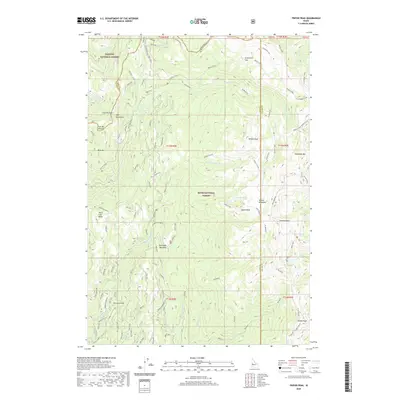
2020 Map of Tripod Peak
USGS Topo · Published 2020About this map
West Mountain dominates this portion of Idaho, marking the boundary between the Payette National Forest and Boise National Forest. The landscape is defined by high ridges and peaks, notably Tripod Peak and Snowbank Mtn, while the drainage system of Squaw Creek and its many branches like Third Fork Squaw Creek carve through the terrain. Human presence is marked by high-altitude infrastructure and historical livestock sites, such as the Tripod Lookout and Wilson Corrals. Natural clearings and watering holes are scattered across the peaks, including Rammage Meadows, Greenfield Flat, and the curiously named Gabes Bathtub. These meadows and flats provide a glimpse into the seasonal use of the high country by foresters and ranchers. Numerous forest roads and spurs, such as Spur 653B and Spur 607A, provide access to this complex topography.
Find a feature on this map
91 named features on this map. Tap any name to fly to it.
Don’t see what you’re looking for? This feature index may not catch every label — zoom into the map to look around manually.
Map Details
Editions of this 2020 Tripod Peak Map
This is the sole edition of this map. No revisions or reprints were ever made.
Other maps of this area

1894 · Squaw Creek
USGS Topo · 1:125,000

1911 · Meadows
USGS Topo · 1:125,000

1953 · Smiths Ferry
USGS Topo · 1:62,500

1954 · Council
USGS Topo · 1:62,500

1954 · Cascade
USGS Topo · 1:62,500

1955 · Baker
USGS Topo · 1:250,000

1959 · Baker
USGS Topo · 1:250,000

1970 · Dodson Pass
USGS Topo · 1:24,000
1970 · Twin Sisters
USGS Topo · 1:24,000

1980 · McCall
USGS Topo · 1:100,000