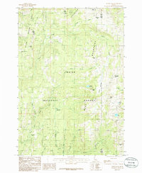
1985 Map of Tripod Peak
USGS Topo · Published 1986About this map
The Boise National Forest and Payette National Forest converge in this high-elevation landscape, where the headwaters of the Squaw Creek system define the drainage patterns. This mid-1980s provisional study documents a region of dramatic vertical relief, anchored by the 7,800-foot heights of Tripod Peak and the communications facilities atop Snowbank Mountain. The presence of several named meadows and flats, such as Wilson Meadows and Rammage Meadows, suggests the importance of these seasonal grazing areas within the timbered slopes. Along the eastern edge, the topography drops toward Blue Lake and Potters Pond, while the curiously named Gabes Bathtub sits below Gabes Peak. This map records the late-century configuration of Forest Service trails and unimproved roads that provided access to the high basins of the Squaw Mountains before modern developments changed the backcountry character.
Find a feature on this map
34 named features on this map. Tap any name to fly to it.
Don’t see what you’re looking for? This feature index may not catch every label — zoom into the map to look around manually.
Map Details
Editions of this 1985 Tripod Peak Map
This is the sole edition of this map. No revisions or reprints were ever made.
Other maps of this area

1894 · Squaw Creek
USGS Topo · 1:125,000

1911 · Meadows
USGS Topo · 1:125,000

1953 · Smiths Ferry
USGS Topo · 1:62,500

1954 · Council
USGS Topo · 1:62,500

1954 · Cascade
USGS Topo · 1:62,500

1955 · Baker
USGS Topo · 1:250,000

1959 · Baker
USGS Topo · 1:250,000

1970 · Dodson Pass
USGS Topo · 1:24,000
1970 · Twin Sisters
USGS Topo · 1:24,000

1980 · McCall
USGS Topo · 1:100,000