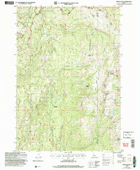
2004 Map of Tripod Peak
USGS Topo · Published 2007About this map
The Boise Mountains define this high-altitude landscape where the boundaries of Gem, Adams, and Valley counties converge. This 2004 revision reveals a terrain managed by the Forest Service, split between the Boise National Forest and Payette National Forest. Notable summits including Tripod Peak, Snowbank Mountain, and Granite Peak dominate the eastern ridge, providing a clear view of the area's geological prominence and the placement of modern infrastructure like communication towers and a lookout helispot.
Find a feature on this map
37 named features on this map. Tap any name to fly to it.
Don’t see what you’re looking for? This feature index may not catch every label — zoom into the map to look around manually.
Map Details
Editions of this 2004 Tripod Peak Map
This is the sole edition of this map. No revisions or reprints were ever made.
Other maps of this area

1894 · Squaw Creek
USGS Topo · 1:125,000

1911 · Meadows
USGS Topo · 1:125,000

1953 · Smiths Ferry
USGS Topo · 1:62,500

1954 · Council
USGS Topo · 1:62,500

1954 · Cascade
USGS Topo · 1:62,500

1955 · Baker
USGS Topo · 1:250,000

1959 · Baker
USGS Topo · 1:250,000

1970 · Dodson Pass
USGS Topo · 1:24,000
1970 · Twin Sisters
USGS Topo · 1:24,000

1980 · McCall
USGS Topo · 1:100,000