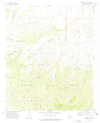
1972 Map of Tripp Canyon
USGS Topo · Published 1975About this map
Coronado National Forest lands dominate this high-desert territory within the Pinaleno Mountains of Graham County. In the early 1970s, this landscape was defined by an extensive network of water management features, including numerous livestock tanks like the Dry Lake Stock Tank and Two Troughs Spring Tank, which supported ranching in an arid environment. The map details a rugged drainage system where Tripp Canyon and Underwood Wash cut through the terrain, alongside historic routes such as the Bellows Trail and Taylor Canyon Trail. For researchers, the inclusion of a single Grave near a Water Tank and the site of Lindsey provides specific points of interest for local history. The presence of a Gaging Station on Cottonwood Creek further highlights the critical monitoring of water resources in this part of Arizona.
Find a feature on this map
54 named features on this map. Tap any name to fly to it.
Don’t see what you’re looking for? This feature index may not catch every label — zoom into the map to look around manually.
Map Details
Editions of this 1972 Tripp Canyon Map
This is the sole edition of this map. No revisions or reprints were ever made.
Other maps of this area

1940 · Sierra Bonita Ranch
USGS Topo · 1:62,500

1942 · Sierra Bonita Ranch
USGS Topo · 1:62,500

1942 · Mt. Graham
USGS Topo · 1:62,500

1943 · Sierra Bonita Ranch
USGS Topo · 1:62,500

1944 · Jackson Mtn.
USGS Topo · 1:62,500

1945 · Mt. Graham
USGS Topo · 1:62,500

1946 · Jackson Mtn.
USGS Topo · 1:62,500

1954 · Silver City
USGS Topo · 1:250,000

1956 · Tucson
USGS Topo · 1:250,000

1958 · Silver City
USGS Topo · 1:250,000