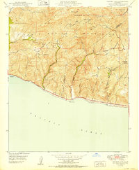
1950 Map of Triunfo Pass
USGS Topo · Published 1950About this map
Solromar sits along the shoreline at the mid-century, marking a small coastal settlement point where the mountains meet the Pacific. This 1950 edition captures the coastal landscape as it was mapped by the Geological Survey during the post-war era under Governor Earl Warren. The drainage of Big Sycamore Can defines the northern reaches of the terrain, providing a look at the natural watercourses before significant modern development altered the drainage patterns of the area. The map illustrates the primary road networks and topography of this coastal stretch as it appeared in 1949 during the field check, offering a snapshot of the region's geography prior to the rapid expansion of later decades.
Find a feature on this map
2 named features on this map. Tap any name to fly to it.
Don’t see what you’re looking for? This feature index may not catch every label — zoom into the map to look around manually.
Map Details
Editions of this 1950 Triunfo Pass Map
2 editions found
Other maps of this area

1900 · Triunfo Pass
USGS Topo · 1:62,500

1903 · Camulos
USGS Topo · 1:125,000

1904 · Hueneme
USGS Topo · 1:62,500

1921 · Triunfo Pass
USGS Topo · 1:62,500

1929 · Dume Point
USGS Topo · 1:24,000

1932 · Dume Point
USGS Topo · 1:24,000

1932 · Russell Valley
USGS Topo · 1:24,000

1932 · Arroyo Sequit
USGS Topo · 1:24,000

1942 · Hueneme
USGS Topo · 1:62,500

1943 · Hueneme
USGS Topo · 1:62,500
Featured Places
- Malibu, CA
- South Beach, CA
- Unincorporated Santa Monica Mountains, CA
- Ventura County, CA
- Los Angeles County, CA