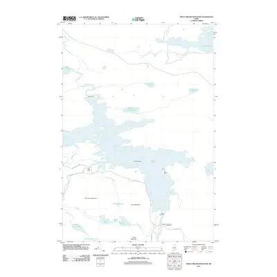
2011 Map of Trout Brook Mountain
USGS Topo · Published 2011About this map
Trout Brook Farm serves as a lone outpost within the northern reaches of Baxter State Park, situated at the convergence of several mountain-fed waterways. The terrain is defined by the complex hydrography of the East Branch Penobscot River watershed, where structures like Norway Dam and Grand Lake Dam manage the flow between Second Lake and various smaller ponds. The landscape is punctuated by notable heights including Trout Brook Mountain, Horse Mountain, and Billfish Mountain. This 2011 survey documents a preserved wilderness area where the legacy of early 20th-century conservation meets modern recreation at the Matagamon Wilderness Campground. The intricate network of brooks, from Littlefield Brook to Billfish Brook, illustrates the remote and watery character of this North Woods region.
Find a feature on this map
33 named features on this map. Tap any name to fly to it.
Don’t see what you’re looking for? This feature index may not catch every label — zoom into the map to look around manually.
Map Details
Editions of this 2011 Trout Brook Mountain Map
This is the sole edition of this map. No revisions or reprints were ever made.
Other maps of this area

1954 · Shin Pond
USGS Topo · 1:62,500

1954 · Millinocket Lake
USGS Topo · 1:62,500

1954 · Grand Lake Seboeis
USGS Topo · 1:62,500

1954 · Presque Isle
USGS Topo · 1:250,000

1955 · Traveler Mountain
USGS Topo · 1:62,500

1958 · Presque Isle
USGS Topo · 1:250,000

1960 · Presque Isle
USGS Topo · 1:250,000
1975 · The Traveler
USGS Topo · 1:24,000
1975 · Shin Pond SW
USGS Topo · 1:24,000
1975 · Shin Pond NW
USGS Topo · 1:24,000