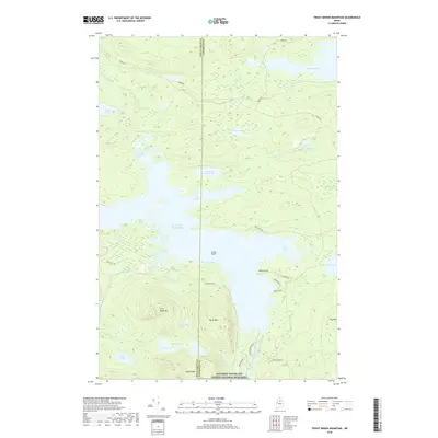
2018 Map of Trout Brook Mountain
USGS Topo · Published 2018About this map
Katahdin Woods and Waters National Monument preserves a vast northern Maine wilderness defined by its complex waterway network and prominent peaks. The eastern half of Grand Lake Matagamon dominates the central landscape, fed by Trout Brook and Boody Brook. To the south, the topography rises sharply at Trout Brook Mtn and Horse Mtn, creating a dramatic backdrop for the East Branch Penobscot River as it flows south from the Matagamon Dam Rd. This 2018 survey illustrates a region where transport is limited to rugged tracks like Huber Rd and Park Tote Rd, reflecting its status as a protected ecological and recreational corridor. Smaller water bodies like Scraggly Lake and the oddly named Mountain Catcher Pond dot the north, while low-lying marshes like Big Logan and Soper Logan reveal the area's glacial drainage patterns.
Find a feature on this map
40 named features on this map. Tap any name to fly to it.
Don’t see what you’re looking for? This feature index may not catch every label — zoom into the map to look around manually.
Map Details
Editions of this 2018 Trout Brook Mountain Map
This is the sole edition of this map. No revisions or reprints were ever made.
Other maps of this area

1954 · Shin Pond
USGS Topo · 1:62,500

1954 · Millinocket Lake
USGS Topo · 1:62,500

1954 · Grand Lake Seboeis
USGS Topo · 1:62,500

1954 · Presque Isle
USGS Topo · 1:250,000

1955 · Traveler Mountain
USGS Topo · 1:62,500

1958 · Presque Isle
USGS Topo · 1:250,000

1960 · Presque Isle
USGS Topo · 1:250,000
1975 · The Traveler
USGS Topo · 1:24,000
1975 · Shin Pond SW
USGS Topo · 1:24,000
1975 · Shin Pond NW
USGS Topo · 1:24,000