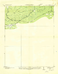
1935 Map of Trout Dale
USGS Topo · Published 1935About this map
Unaka National Forest dominates the terrain of this 1935 Tennessee Valley Authority and USGS advance sheet, where the high ridges of the Unaka Mountains and Iron Mountain converge. The survey illustrates a mid-1930s mountain landscape at the border of Smyth and Grayson Counties, defined by a network of early motor routes and footpaths. The Appalachian Trail winds through the southern portion of the sheet, crossing high points near Locust Ridge and Comers Creek. Transport corridors like the J.E.B. Stuart Highway and U.S. Highway No 58 suggest the era's focus on connecting these once-isolated highlands. Numerous family-named drainage features, such as Mullins Branch, Houndshell Branch, and Slabtown Br, provide specific geographic markers for genealogists tracing ancestral land in this part of southwest Virginia.
Find a feature on this map
34 named features on this map. Tap any name to fly to it.
Don’t see what you’re looking for? This feature index may not catch every label — zoom into the map to look around manually.
Map Details
Editions of this 1935 Trout Dale Map
This is the sole edition of this map. No revisions or reprints were ever made.
Other maps of this area

1889 · Wytheville
USGS Topo · 1:125,000

1891 · Abingdon
USGS Topo · 1:125,000

1892 · Wytheville
USGS Topo · 1:125,000

1894 · Abingdon
USGS Topo · 1:125,000

1909 · Abingdon
USGS Topo · 1:96,000

1911 · Abingdon
USGS Topo · 1:125,000

1931 · Rural Retreat
USGS Topo · 1:48,000

1935 · Mouth of Wilson
USGS Topo · 1:48,000

1935 · Park
USGS Topo · 1:24,000

1935 · Mount Rogers
USGS Topo · 1:48,000