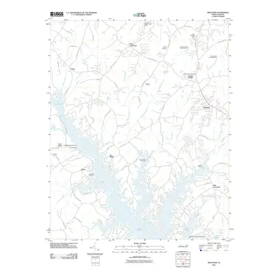
2010 Map of Troutman
USGS Topo · Published 2010About this map
Lake Norman dominates the southern half of this landscape, its intricate shoreline creating numerous points and coves such as those near Monbo and East Monbo. The topography reflects a transitioned rural environment where traditional agricultural crossroads like Kyles Crossroads and Bells Crossroads meet modern recreational development. Further north, the community of Barium Springs is a central point of interest, featuring the Barium Springs Post Office and the Barium Spring Orphanage Dam. Local history is preserved in several burial grounds, including Saint Martins Cemetery and Concord Cemetery, which sit alongside established family-named landmarks like Troutman Farm Rd. The town of Troutman serves as the primary hub in the eastern portion of the map, situated at the junction of several key local roads and the headwaters of numerous small branches and creeks.
Find a feature on this map
83 named features on this map. Tap any name to fly to it.
Don’t see what you’re looking for? This feature index may not catch every label — zoom into the map to look around manually.
Map Details
Editions of this 2010 Troutman Map
This is the sole edition of this map. No revisions or reprints were ever made.
Other maps of this area

1893 · Statesville
USGS Topo · 1:125,000

1895 · Hickory
USGS Topo · 1:125,000

1953 · Charlotte
USGS Topo · 1:250,000

1954 · Charlotte
USGS Topo · 1:250,000

1960 · Charlotte
USGS Topo · 1:250,000

1962 · Charlotte
USGS Topo · 1:250,000

1969 · Shepherds
USGS Topo · 1:24,000

1969 · Troutman
USGS Topo · 1:24,000
1969 · Mooresville
USGS Topo · 1:24,000

1969 · Statesville West
USGS Topo · 1:24,000