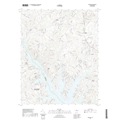
2019 Map of Troutman
USGS Topo · Published 2019About this map
Lake Norman of Catawba dominates the southern half of this landscape, its intricate shoreline following the contours of flooded creek valleys like Stumpy Cr and Hicks Cr. This modern survey captures the region's character as a mix of lakeside residential growth and established crossroads communities. Near the center, Troutman serves as a primary hub, situated east of the extensive lake branches. The map details the transition from rural Iredell County roads to the sprawling developments along the water, including the Long Island Airport and the distinct peninsula of Long Island. Genealogical researchers can locate several burial grounds preserved among the newer infrastructure, such as Saint Martins Cem near Kyles Crossroads and Pine Grove Cem north of the Monbo area. The NS rail line runs north-south through the eastern corridor, connecting the settlements of Barium Springs and Troutman.
Find a feature on this map
234 named features on this map. Tap any name to fly to it.
Don’t see what you’re looking for? This feature index may not catch every label — zoom into the map to look around manually.
Map Details
Editions of this 2019 Troutman Map
This is the sole edition of this map. No revisions or reprints were ever made.
Other maps of this area

1893 · Statesville
USGS Topo · 1:125,000

1895 · Hickory
USGS Topo · 1:125,000

1953 · Charlotte
USGS Topo · 1:250,000

1954 · Charlotte
USGS Topo · 1:250,000

1960 · Charlotte
USGS Topo · 1:250,000

1962 · Charlotte
USGS Topo · 1:250,000

1969 · Shepherds
USGS Topo · 1:24,000

1969 · Troutman
USGS Topo · 1:24,000
1969 · Mooresville
USGS Topo · 1:24,000

1969 · Statesville West
USGS Topo · 1:24,000