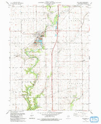
1993 Map of Troy Grove
USGS Topo · Published 1993About this map
Troy Grove sits at the heart of this LaSalle County landscape, where the Vermilion River and Tomahawk Creek converge. The terrain is defined by the sharp incision of these waterways into the prairie, most notably at Tomahawk Bluff, providing a dramatic contrast to the surrounding agricultural grid. This survey captures the transition of the local economy, where traditional farming in townships like Ophir and Waltham exists alongside industrial extraction. Large Sandpits and a Quarry near the village of Troy Grove reveal the importance of the area's geological resources.
Find a feature on this map
33 named features on this map. Tap any name to fly to it.
Don’t see what you’re looking for? This feature index may not catch every label — zoom into the map to look around manually.
Map Details
Editions of this 1993 Troy Grove Map
This is the sole edition of this map. No revisions or reprints were ever made.
Other maps of this area

1892 · Ottawa
USGS Topo · 1:62,500

1893 · Lasalle
USGS Topo · 1:62,500

1911 · La Salle
USGS Topo · 1:62,500

1913 · La Salle
USGS Topo · 1:62,500

1915 · Ottawa
USGS Topo · 1:62,500

1946 · Ottawa
USGS Topo · 1:62,500

1947 · La Salle
USGS Topo · 1:62,500

1951 · Earlville
USGS Topo · 1:62,500

1952 · Mendota
USGS Topo · 1:62,500

1958 · Aurora
USGS Topo · 1:250,000