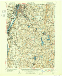
1950 Map of Troy
USGS Topo · Published 1950About this map
The Hudson River corridor serves as the industrial and transit spine of this mid-century New York landscape, where the bustling urban centers of Troy and Watervliet give way to the rugged hill country of Rensselaer County. This 1950 edition, based on earlier surveys and updated after the war, reveals a complex network of established institutions like the Rensselaer Polytechnic Inst and numerous religious landmarks including St Josephs Cemetery and St Marys Church.
Find a feature on this map
127 named features on this map. Tap any name to fly to it.
Don’t see what you’re looking for? This feature index may not catch every label — zoom into the map to look around manually.
Map Details
Editions of this 1950 Troy Map
This is the sole edition of this map. No revisions or reprints were ever made.
Other maps of this area

1888 · Berlin
USGS Topo · 1:62,500

1888 · Pittsfield
USGS Topo · 1:62,500

1890 · Pittsfield
USGS Topo · 1:62,500

1890 · Berlin
USGS Topo · 1:62,500

1893 · Cohoes
USGS Topo · 1:62,500

1893 · Troy
USGS Topo · 1:62,500

1893 · Schenectady
USGS Topo · 1:62,500

1893 · Coxsackie
USGS Topo · 1:62,500

1893 · Pittsfield
USGS Topo · 1:62,500

1893 · Albany
USGS Topo · 1:62,500