
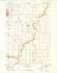
1967 Map of Truman
USGS Topo · Published 1968About this map
Truman serves as the central hub of this mid-1960s agricultural landscape, situated at the junction of the Chicago and North Western railway and several local transport arteries. The survey reveals a region defined by its water and conservation efforts, most notably the Perch Creek State Wildlife Management Area and the chain of water bodies including Perch Lake, Murphy Lake, and Martin Lake in the southern reaches. The abundance of burial grounds, such as Ridge Lawn Cem, St Paul Cem, and Antrim-St John Cem, provides a detailed record of early settlement patterns across the townships of Antrim and Westford. The drainage of the land is meticulously mapped through features like the South Branch of the Watonwan River, Mink Creek, and Elm Creek, while industrial activity is noted by several Gravel Pits and the presence of a substantial Pipeline traversing the prairie.
Find a feature on this map
29 named features on this map. Tap any name to fly to it.
Don’t see what you’re looking for? This feature index may not catch every label — zoom into the map to look around manually.
Map Details
Editions of this 1967 Truman Map
This is the sole edition of this map. No revisions or reprints were ever made.
Other maps of this area

1954 · Fairmont
USGS Topo · 1:250,000

1958 · Fairmont
USGS Topo · 1:250,000

1967 · Truman SE
USGS Topo · 1:24,000

1967 · Willow Creek
USGS Topo · 1:24,000

1967 · Lewisville
USGS Topo · 1:24,000

1967 · Granada
USGS Topo · 1:24,000

1967 · Fairmont
USGS Topo · 1:24,000

1970 · St James SE
USGS Topo · 1:24,000
1970 · St James East
USGS Topo · 1:24,000

1970 · Welcome
USGS Topo · 1:24,000