
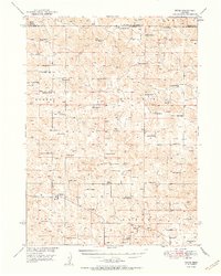
1951 Map of Tryon
USGS Topo · Published 1951About this map
Tryon serves as the focal point of this McPherson County landscape, which in the early 1950s was defined by an extensive network of family-operated ranches and small district schools. The terrain is characterized by the distinct topography of the Sandhills, where labels like Worden and Seneca mark broad geographic reaches between the numerous valleys. The settlement pattern here is remarkably decentralized, consisting almost entirely of isolated ranching hubs such as McClintock Ranch, Waits Ranch, and Roggenthen Ranch.
Find a feature on this map
55 named features on this map. Tap any name to fly to it.
Don’t see what you’re looking for? This feature index may not catch every label — zoom into the map to look around manually.
Map Details
Editions of this 1951 Tryon Map
2 editions found
Other maps of this area

1898 · Paxton
USGS Topo · 1:125,000

1899 · North Platte
USGS Topo · 1:125,000

1901 · Paxton
USGS Topo · 1:125,000

1902 · North Platte
USGS Topo · 1:125,000

1947 · Dismal River Ranch
USGS Topo · 1:62,500

1948 · Thedford
USGS Topo · 1:62,500

1949 · Dismal River Ranch
USGS Topo · 1:62,500

1949 · Cody Lake
USGS Topo · 1:62,500

1949 · Wright Valley
USGS Topo · 1:62,500

1950 · Thedford
USGS Topo · 1:62,500