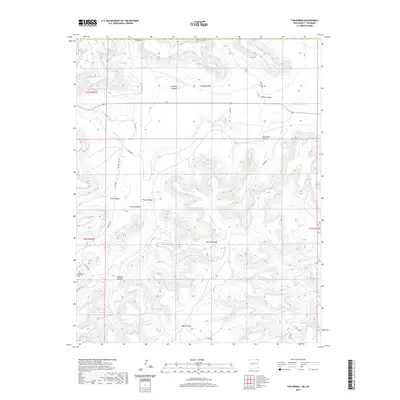
2020 Map of Tub Spring
USGS Topo · Published 2020About this map
Dry Cimarron River courses through this high-plains landscape along the border of Las Animas County and New Mexico. The terrain is defined by a dense network of canyons and draws, including Flathead Canyon and Miller Canyon to the north, which give way to Anderson Canyon and the winding Peacock Draw. The topographic data reveals a complex drainage pattern where seasonal waterways have carved deep into the mesas, creating prominent landmarks such as Peacock Hill.
Find a feature on this map
26 named features on this map. Tap any name to fly to it.
Don’t see what you’re looking for? This feature index may not catch every label — zoom into the map to look around manually.
Map Details
Editions of this 2020 Tub Spring Map
This is the sole edition of this map. No revisions or reprints were ever made.
Other maps of this area

1892 · Mt Carrizo
USGS Topo · 1:125,000

1954 · Dalhart
USGS Topo · 1:250,000

1955 · La Junta
USGS Topo · 1:250,000

1958 · La Junta
USGS Topo · 1:250,000

1958 · Dalhart
USGS Topo · 1:250,000

1962 · Dalhart
USGS Topo · 1:250,000

1968 · La Junta
USGS Topo · 1:250,000
1972 · Wedding Cake Butte
USGS Topo · 1:24,000

1972 · Travesser Park
USGS Topo · 1:24,000
1972 · Guy
USGS Topo · 1:24,000