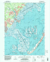
1995 Map of Tuckerton
USGS Topo · Published 1998About this map
Tuckerton and its neighboring boroughs of West Tuckerton and Giffordtown center this coastal study, illustrating the complex relationship between mainland New Jersey settlements and the shifting marshlands of the Atlantic coast. The landscape is defined by extensive tidal wetlands and thoroughfares, with much of the terrain preserved within the Edwin B Forsythe National Wildlife Refuge and the Great Bay Boulevard State Wildlife Management Area. Cultural landmarks such as the Pulaski Monument and Greenwood Cem stand near the developed corridors, while the maritime economy is evidenced by Parkers Landing and a Fish Factory located deep within the marshes near Seven Islands. Across the waters of Little Egg Harbor, the barrier island communities of Beach Haven and Holgate occupy the narrow strip of Long Beach, connected to the mainland by the winding path of Great Bay Boulevard.
Find a feature on this map
87 named features on this map. Tap any name to fly to it.
Don’t see what you’re looking for? This feature index may not catch every label — zoom into the map to look around manually.
Map Details
Editions of this 1995 Tuckerton Map
This is the sole edition of this map. No revisions or reprints were ever made.
Other maps of this area

1887 · Atlantic City
USGS Topo · 1:62,500

1888 · Little Egg Harbor
USGS Topo · 1:62,500

1888 · Long Beach
USGS Topo · 1:62,500

1893 · Little Egg Harbor
USGS Topo · 1:62,500

1893 · Long Beach
USGS Topo · 1:62,500

1894 · Atlantic City
USGS Topo · 1:62,500

1919 · Long Beach
USGS Topo · 1:62,500

1920 · Little Egg Harbor
USGS Topo · 1:62,500

1940 · Atlantic City
USGS Topo · 1:62,500
1941 · Atlantic City
USGS Topo · 1:62,500
Featured Places
- Galloway Township, NJ
- Little Egg Harbor Township, NJ
- Tuckerton, NJ
- Long Beach Township, NJ
- Eagleswood Township, NJ