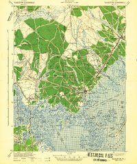
1942 Map of Tuckerton
USGS Topo · Published 1942About this map
Little Egg Harbor and the intricate wetlands of the New Jersey coast define this early wartime survey, which details a landscape balanced between maritime activity and the deep Pine Barrens. The settlement of Tuckerton serves as the focal point, connected to the mainland's interior via the Tuckerton RR and surrounded by smaller communities like Giffordtown, Parkertown, and West Creek. The interior is heavily marked by industrial and conservation efforts, including the Cranberry Bogs near Sim Place and the expansive reaches of Penn State Forest and Bass River State Forest. Notable for local history is the presence of the Tuckerton Radio station near the coast and the numerous named sediment features like West Sedge and Middle Sedge that shift with the tides of the Inland Waterway.
Find a feature on this map
127 named features on this map. Tap any name to fly to it.
Don’t see what you’re looking for? This feature index may not catch every label — zoom into the map to look around manually.
Map Details
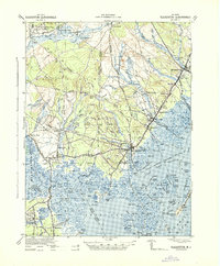
Editions of this 1942 Tuckerton Map
2 editions found
Other maps of this area

1884 · Whitings
USGS Topo · 1:62,500

1887 · Atlantic City
USGS Topo · 1:62,500

1888 · Pemberton
USGS Topo · 1:62,500

1888 · Barnegat
USGS Topo · 1:62,500

1888 · Little Egg Harbor
USGS Topo · 1:62,500

1888 · Long Beach
USGS Topo · 1:62,500

1888 · Whitings
USGS Topo · 1:62,500

1890 · Great Egg Harbor
USGS Topo · 1:62,500

1890 · Mullica
USGS Topo · 1:62,500

1893 · Great Egg Harbor
USGS Topo · 1:62,500
Featured Places
- Galloway Township, NJ
- Stafford Township, NJ
- Barnegat Township, NJ
- Little Egg Harbor Township, NJ
- Tuckerton, NJ