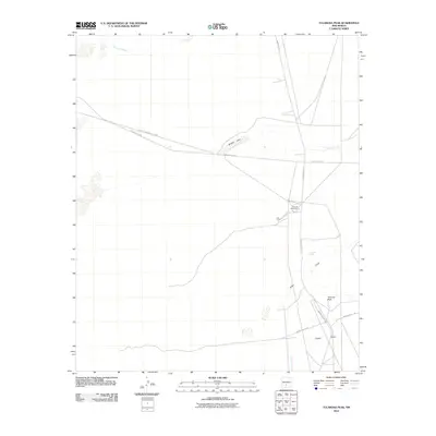
2010 Map of Tularosa Peak
USGS Topo · Published 2010About this map
White Sands Missile Range dominates this high-desert landscape in Otero County, where military infrastructure and natural drainage patterns define the territory. The presence of Tularosa Range Camp and a network of restricted routes, such as WSMR P Route 9 and WSMR P Route 6, underscore the area's ongoing role in national defense. The desert floor is carved by ephemeral waterways like Temporal Creek and Tularosa Creek, which occasionally feed into Brazel Lake. Rising from the basin, the prominent Tularosa Peak serves as a stark landmark, while localized features like Harkness Spring and Guilez Draw indicate the subtle shifts in elevation and hydrology that characterize this portion of the basin. The map illustrates the specialized road system used for range operations, contrasting the undeveloped terrain with the precision of military logistical planning.
Find a feature on this map
15 named features on this map. Tap any name to fly to it.
Don’t see what you’re looking for? This feature index may not catch every label — zoom into the map to look around manually.
Map Details
Editions of this 2010 Tularosa Peak Map
This is the sole edition of this map. No revisions or reprints were ever made.
Other maps of this area

1916 · Tularosa
USGS Topo · 1:125,000

1916 · Point Of Sands
USGS Topo · 1:125,000

1947 · Point Of Sands 2
USGS Topo · 1:62,500

1948 · Lumley Lake
USGS Topo · 1:62,500

1948 · Tularosa
USGS Topo · 1:62,500

1948 · Holloman
USGS Topo · 1:62,500

1954 · Tularosa
USGS Topo · 1:250,000

1955 · Las Cruces
USGS Topo · 1:250,000

1958 · Las Cruces
USGS Topo · 1:250,000

1958 · Tularosa
USGS Topo · 1:250,000