
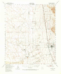
1948 Map of Tularosa
USGS Topo · Published 1956About this map
The town of Tularosa sits at the foot of the desert highlands, where the Tularosa River and Rinconada Creek emerge from the mountains. This mid-century landscape is defined by its transition from ranching to military research, with the vast expanse of The Sands and White Sands dominating the western half of the quadrangle. The map documents the Alamogordo Bombing Range Proving Ground and the California Institute of Technology Ordnance Bombing Range, illustrating how the desert terrain was utilized for post-war technological testing. Remote outposts like Stover Ranch and Purday Ranch appear alongside specialized infrastructure such as the Tularosa Range Camp and various Airstrips. The Southern Pacific railroad provides a critical transit line through the valley, connecting the high desert settlements to the broader region.
Find a feature on this map
44 named features on this map. Tap any name to fly to it.
Don’t see what you’re looking for? This feature index may not catch every label — zoom into the map to look around manually.
Map Details
Editions of this 1948 Tularosa Map
2 editions found
Other maps of this area

1916 · Tularosa
USGS Topo · 1:125,000

1916 · Point Of Sands
USGS Topo · 1:125,000

1947 · Point Of Sands 2
USGS Topo · 1:62,500

1947 · Three Rivers
USGS Topo · 1:62,500

1947 · Capitol Peak
USGS Topo · 1:62,500

1948 · Lumley Lake
USGS Topo · 1:62,500

1948 · Holloman
USGS Topo · 1:62,500

1950 · Three Rivers
USGS Topo · 1:24,000

1950 · Alamogordo
USGS Topo · 1:62,500

1950 · Sierra Blanca Peak
USGS Topo · 1:62,500