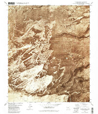
1981 Map of Tularosa Peak
USGS Topo · Published 1982About this map
White Sands dominate the western portion of this 1980s orthophotomap, where wind-driven Shifting Sand patterns are visible alongside the heavy infrastructure of the White Sands Missile Range. This composite photographic and topographic study reveals the specialized landscape of the Tularosa Basin, including the northern reaches of Holloman Air Force Base and its distinctive High Speed Test Track.
Find a feature on this map
24 named features on this map. Tap any name to fly to it.
Don’t see what you’re looking for? This feature index may not catch every label — zoom into the map to look around manually.
Map Details
Editions of this 1981 Tularosa Peak Map
This is the sole edition of this map. No revisions or reprints were ever made.
Other maps of this area

1916 · Tularosa
USGS Topo · 1:125,000

1916 · Point Of Sands
USGS Topo · 1:125,000

1947 · Point Of Sands 2
USGS Topo · 1:62,500

1948 · Lumley Lake
USGS Topo · 1:62,500

1948 · Tularosa
USGS Topo · 1:62,500

1948 · Holloman
USGS Topo · 1:62,500

1954 · Tularosa
USGS Topo · 1:250,000

1955 · Las Cruces
USGS Topo · 1:250,000

1958 · Las Cruces
USGS Topo · 1:250,000

1958 · Tularosa
USGS Topo · 1:250,000