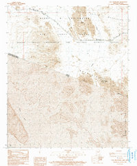
1990 Map of Tule Mountains
USGS Topo · Published 1991About this map
The Camino Del Diablo, an ancient and treacherous route through the Sonoran Desert, dominates the northern half of this borderlands survey. This 1990 map captures the stark intersection of military administration and ecological preservation, where the Barry M Goldwater Air Force Range meets the Cabeza Prieta Wilderness and National Wildlife Refuge. The international boundary between the United States and Mexico cuts across the center, revealing the southern reaches of the Tule Mountains and the northern extent of the Sierra El Choclo Duro in Sonora. Essential water sources for travelers, such as Tule Tank and Buckhorn Tank, are documented alongside mining evidence at the Venegas Prospects. This map provides a rare look at how the Cabeza Prieta Mountains cross-cut contemporary political and military jurisdictions.
Find a feature on this map
15 named features on this map. Tap any name to fly to it.
Don’t see what you’re looking for? This feature index may not catch every label — zoom into the map to look around manually.
Map Details
Editions of this 1990 Tule Mountains Map
This is the sole edition of this map. No revisions or reprints were ever made.
Other maps of this area

1953 · Ajo
USGS Topo · 1:250,000

1957 · Ajo
USGS Topo · 1:250,000

1958 · Ajo
USGS Topo · 1:250,000

1962 · Ajo
USGS Topo · 1:250,000

1963 · Ajo
USGS Topo · 1:250,000

1965 · Cabeza Prieta Peak
USGS Topo · 1:62,500
1965 · Tule Mountains
USGS Topo · 1:62,500

1965 · Isla Pinta
USGS Topo · 1:62,500

1965 · Sierra Arida
USGS Topo · 1:62,500

1967 · Ajo
USGS Topo · 1:250,000