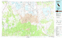
1984 Map of Tulelake
USGS Topo · Published 1985About this map
The Lava Beds National Monument dominates the center of this 1984 survey, revealing a landscape defined by volcanic geology and intensive water management. Straddling the Oregon California border, the region displays a complex system of sumps and canals, notably the Lower Klamath Lake Sump and Tule Lake Sump, which support the vast Lower Klamath National Wildlife Refuge. The settlement pattern follows the rail lines and irrigation borders, with towns like Tulelake and Stronghold positioned near the reclaimed lake beds. To the south, the terrain rises into the timberlands of the Modoc National Forest and Shasta National Forest, where features like Pumice Stone Mtn and the Burnt Lava Flow Virgin Area highlight the area's raw geothermal history. Transit is anchored by the Southern Pacific and Burlington Northern railroads, which once moved the region's agricultural and timber yields through the high desert.
Find a feature on this map
227 named features on this map. Tap any name to fly to it.
Don’t see what you’re looking for? This feature index may not catch every label — zoom into the map to look around manually.
Map Details
Editions of this 1984 Tulelake Map
2 editions found
Other maps of this area

1886 · Alturas
USGS Topo · 1:250,000

1886 · Modoc Lava Bed
USGS Topo · 1:250,000

1886 · Shasta
USGS Topo · 1:250,000

1889 · Klamath
USGS Topo · 1:250,000

1891 · Ashland
USGS Topo · 1:250,000

1892 · Modoc Lava-Bed
USGS Topo · 1:250,000

1892 · Alturas
USGS Topo · 1:250,000

1893 · Ashland
USGS Topo · 1:250,000

1894 · Klamath
USGS Topo · 1:250,000

1894 · Shasta
USGS Topo · 1:250,000