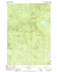
1989 Map of Tumbledown Mtn
USGS Topo · Published 1989About this map
Tumbledown Mtn and Three Slide Mtn dominate this 1980s landscape in the North Maine Woods, a region defined by its complex network of logging roads and high-elevation water bodies. The terrain is deeply carved by the West Branch Spencer Stream and its numerous tributaries, including Sweetster Bk and Spoulding Brook. While the area lacks traditional towns, it shows the active industrial use of the land through a Gravel Pit and an extensive system of unimproved roads that navigate the steep slopes of No 6 Mountain and Spencer Bale Mtn. This map captures a moment when the wilderness was managed for timber, as evidenced by the township boundaries like Appleton and Hobbstown. Remote water features such as Blakeslee Lake, Rock Pond, and Davis Pond offer significant points of reference for those tracing the history of Maine's backcountry sporting and timber heritage.
Find a feature on this map
33 named features on this map. Tap any name to fly to it.
Don’t see what you’re looking for? This feature index may not catch every label — zoom into the map to look around manually.
Map Details
Editions of this 1989 Tumbledown Mtn Map
This is the sole edition of this map. No revisions or reprints were ever made.
Other maps of this area

1923 · Attean
USGS Topo · 1:62,500

1925 · Attean
USGS Topo · 1:62,500

1928 · Chain Lakes
USGS Topo · 1:48,000

1928 · Skinner
USGS Topo · 1:48,000

1928 · Spencer
USGS Topo · 1:48,000

1931 · Skinner
USGS Topo · 1:62,500

1932 · Spencer
USGS Topo · 1:62,500

1932 · Chain Lakes
USGS Topo · 1:62,500

1935 · Chain Lakes
USGS Topo · 1:62,500

1949 · Jackman
USGS Topo · 1:250,000
Featured Places
- Haynestown Township, ME
- Kibby Township, ME
- Rayton Township, ME
- Skinner Township, ME
- Appleton Township, ME