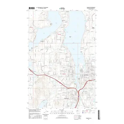
2017 Map of Tumwater
USGS Topo · Published 2017About this map
The Olympia and Tumwater urban corridors define this 2017 study of the southern Puget Sound, where the Deschutes River meets the tide at Capitol Lake. This landscape is deeply shaped by its complex glacial shoreline, featuring a series of peninsulas and inlets including Eld Inlet, Budd Inlet, and Gull Harbor. The map reveals a high concentration of educational and public infrastructure, prominently marking The Evergreen State Coll nestled near Eld Inlet and the S Puget Sound Community Coll further south. Residential developments like Countryside Beach and North Olympia are interspersed with significant freshwater bodies such as Black Lake and Grass Lake. Navigational features like the Entrance Channel and Outer Channel highlight the maritime activity central to the state capital's economy, while inland parks such as Priest Point provide a view of the area's maintained green spaces amidst 21st-century growth.
Find a feature on this map
68 named features on this map. Tap any name to fly to it.
Don’t see what you’re looking for? This feature index may not catch every label — zoom into the map to look around manually.
Map Details
Editions of this 2017 Tumwater Map
This is the sole edition of this map. No revisions or reprints were ever made.
Other maps of this area

1916 · Chehalis
USGS Topo · 1:125,000

1937 · Olympia
USGS Topo · 1:62,500

1939 · Shelton
USGS Topo · 1:62,500

1940 · Tenino
USGS Topo · 1:62,500

1941 · Gate
USGS Topo · 1:62,500

1944 · Tenino
USGS Topo · 1:62,500

1949 · Tenino
USGS Topo · 1:62,500

1949 · Olympia
USGS Topo · 1:62,500

1953 · Hoquiam
USGS Topo · 1:250,000

1953 · Rochester
USGS Topo · 1:62,500