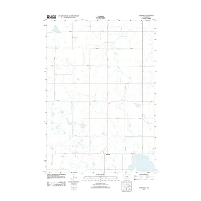
2012 Map of Tunerville
USGS Topo · Published 2012About this map
Tunerville anchors this Deuel County landscape, situated amidst a grid of rural roads that define the agricultural character of eastern South Dakota. The terrain is characterized by numerous small glacial depressions and wetlands, with the larger Lake Alice and Midway Lake serving as prominent local landmarks. Waterways like the S Fork Yellow Bank River and Caine Cr meander through the northern and eastern sections of the quadrangle, indicating the natural drainage patterns of the region. For those tracing family roots in Goodwin Township, the Nelson Cem remains a critical point of historical reference. This 2012 survey illustrates the enduring rural structure of the area, where the intersection of 172nd St and 476th Ave marks the small community hub of Tunerville.
Find a feature on this map
21 named features on this map. Tap any name to fly to it.
Don’t see what you’re looking for? This feature index may not catch every label — zoom into the map to look around manually.
Map Details
Editions of this 2012 Tunerville Map
This is the sole edition of this map. No revisions or reprints were ever made.
Other maps of this area

1953 · Milbank
USGS Topo · 1:250,000

1953 · Watertown
USGS Topo · 1:250,000

1958 · Milbank
USGS Topo · 1:250,000

1958 · Watertown
USGS Topo · 1:250,000

1970 · Bemis
USGS Topo · 1:24,000

1970 · Goodwin
USGS Topo · 1:24,000

1973 · LaBolt
USGS Topo · 1:24,000

1973 · Tunerville
USGS Topo · 1:24,000

1973 · Stockholm
USGS Topo · 1:24,000
1973 · Revillo
USGS Topo · 1:24,000