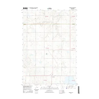
2015 Map of Tunerville
USGS Topo · Published 2015About this map
The Coteau des Prairies plateau defines the geography of this Deuel County landscape, where the town of Tunerville sits near the headwaters of regional drainages. This high prairie region, documented in the mid-2010s, is characterized by a dense network of glacial wetlands and water bodies, including Lake Alice and Midway Lake. The land is divided by a rigid grid of local routes like 165th ST and 172nd ST, illustrating the enduring influence of the Public Land Survey System on South Dakota's rural development.
Find a feature on this map
23 named features on this map. Tap any name to fly to it.
Don’t see what you’re looking for? This feature index may not catch every label — zoom into the map to look around manually.
Map Details
Editions of this 2015 Tunerville Map
This is the sole edition of this map. No revisions or reprints were ever made.
Other maps of this area

1953 · Milbank
USGS Topo · 1:250,000

1953 · Watertown
USGS Topo · 1:250,000

1958 · Milbank
USGS Topo · 1:250,000

1958 · Watertown
USGS Topo · 1:250,000

1970 · Bemis
USGS Topo · 1:24,000

1970 · Goodwin
USGS Topo · 1:24,000

1973 · LaBolt
USGS Topo · 1:24,000

1973 · Tunerville
USGS Topo · 1:24,000

1973 · Stockholm
USGS Topo · 1:24,000
1973 · Revillo
USGS Topo · 1:24,000