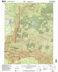
2001 Map of Tuolumne
USGS Topo · Published 2004About this map
Tuolumne serves as the primary hub of this landscape, situated near the western edge of the Stanislaus National Forest. The map documents a historical reliance on extractive industries and ranching, evidenced by the cluster of mining sites north of town including the Ophir Mine, Cherokee Mine, and Columbus Mine. Further north, the Arastraville Sch and the community of Arastraville reflect early 20th-century settlement patterns in the foothills.
Find a feature on this map
64 named features on this map. Tap any name to fly to it.
Don’t see what you’re looking for? This feature index may not catch every label — zoom into the map to look around manually.
Map Details
Editions of this 2001 Tuolumne Map
This is the sole edition of this map. No revisions or reprints were ever made.
Other maps of this area

1891 · Big Trees
USGS Topo · 1:125,000

1893 · Sonora
USGS Topo · 1:125,000

1894 · Big Trees
USGS Topo · 1:125,000

1896 · Sonora
USGS Topo · 1:125,000

1897 · Sonora
USGS Topo · 1:125,000

1897 · Big Trees
USGS Topo · 1:125,000

1898 · Sonora
USGS Topo · 1:125,000

1901 · Big Trees
USGS Topo · 1:125,000

1947 · Sacramento
USGS Topo · 1:250,000

1947 · San Jose
USGS Topo · 1:250,000