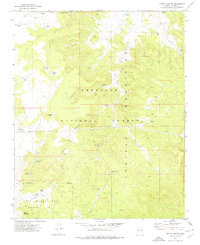
1973 Map of Turkey Canyon
USGS Topo · Published 1977About this map
The Juniper Mountains dominate this high-desert landscape in northern Yavapai County, where water management defines human activity. This 1973 survey reveals an intricate network of infrastructure essential for ranching and mining within the Prescott National Forest. Dozens of named water sources, such as Deep Well Tank, Wolf Tank, and Happy Camp Tank, are scattered across the terrain to support livestock, alongside the Turkey Canyon Well and a New Water Windmill. In the northeast corner, the Iron King Mine indicates the region's mineral extraction history. A notable boundary for the Luis Maria Baca Float No 5 runs across the southern portion of the sheet, reflecting the complex history of Spanish land grants and nineteenth-century land claims that persisted into modern topographic records. Travel across the area is largely limited to a network of Jeep Trails and unnamed roads connecting high points like Haystack Peak and Deer Mountain.
Find a feature on this map
34 named features on this map. Tap any name to fly to it.
Don’t see what you’re looking for? This feature index may not catch every label — zoom into the map to look around manually.
Map Details
Editions of this 1973 Turkey Canyon Map
This is the sole edition of this map. No revisions or reprints were ever made.
Other maps of this area

1886 · Diamond Creek
USGS Topo · 1:250,000

1886 · Chino
USGS Topo · 1:250,000

1887 · Prescott
USGS Topo · 1:250,000

1891 · Chino
USGS Topo · 1:250,000

1892 · Diamond Creek
USGS Topo · 1:250,000

1892 · Prescott
USGS Topo · 1:250,000

1923 · Signal
USGS Topo · 1:250,000

1942 · Signal
USGS Topo · 1:250,000

1947 · Turkey Canyon
USGS Topo · 1:62,500

1947 · Camp Wood
USGS Topo · 1:62,500